A MAP OF MURANGA COUNTY
Kshs 695.00
Kshs Loading...
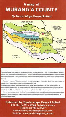
Has seven constituencies namely, Kigumo, Kiharu, Kangema, Maragua, Kandara, Gatanga, and Mathioya. The county is expansive and stretches from Sabasaba-Murang’a highway to Aberdare Forest.
Murang’a County is located between Kiambu County to the South, Nyeri County to the North, Nyandarua County to the West and Kirinyaga County to the East. Murang’a is breath taking with hills, forests, rivers and valleys. The major river Mathioya flows into Tana River.
Attractions in Murang’a County include Kenyan best kept secret Aberdare Ranges. The Aberdares is one of the most important water catchment areas and supplies 55% of the water to Nairobi. Ndakaini Dam also supplies water to Nairobi. There is also the Mukure wa Nyagathanga.
The main cash crops are Tea, Coffee, and Macadamia.
ISBN : 126014042
10 in stock